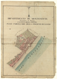
The Napoleonic Cadastre in the Province of Savona
During the Napoleonic Empire, the need emerged for the creation of a tool useful for taking the census and especially for taxing the territory and thus was launched the extraordinary venture of the Cadastre. This represented first and foremost an extremely important innovation in the fiscal management of the State, but also registered, at once both prompting and receiving them, major advances in the representation of the territory. The key characteristics of the Napoleonic Cadastre, appreciable in the maps that have survived to our own day, are their accurate description of the territory and the modernity of the surveying technique. Moreover, the metric decimal system was adopted for the surveys of the entire Empire.
In the territory of the province of Savona, the procedures for surveying and compilation were undertaken between 1808 and 1815, directed by the prefect of the Department of Montenotte Chabrol de Volcic, named directly by Napoleon. The process was based on a system of topographical measurements and estimation of the different crops planted in the area, at first classified according to the mass of cultivation and later, starting from 1808, modified to the particle form.
The maps were rendered in Chinese ink with markings in watercolour.
Archivio di Stato (State Archive)
Via Piave, 21
Turin
Archivio di Stato
Via Quadra Superiore,7
Savona


